Heritage
Historical tours given in an entertaining, enthusiastic and above all knowledgeable fashion by the owner, Patrick Nordstrom, can be arranged for individuals and groups of all sizes as there is an abundance of features on the grounds to fascinate all those who appreciate Irish Heritage. Blackwater Castle itself dates from the twelfth century however there are archaeological features predating the erection of the Castle for you to explore. The history of the site extends back some thousands of years and we know that the site was first occupied during the early Mesolithic period (circa 10,000+ years ago). There is also evidence of occupation of the site during the late Bronze Age and early Iron Age (c. 500 BC) when the fort of Dún Cruadha was established on the current site of Blackwater Castle. Click here for a more detailed account of the history of the Castle.
Caves and Flint Scatters on the banks of the River Awbeg
Caves on the south bank of the Awbeg opposite the Castle were likely occupied by early human settlements being situated on fertile ground near a freshwater spring and adjacent to an extensive river system for navigation which also provided a food source. This, coupled with the flint scatter found in nearby Kilcummer, less than a mile away, confirms that the area was an established site of settlement in the early Mesolithic era making it one of the first known sites in Ireland to be settled when our very first inhabitants likely made their way across a land bridge or via boat from modern day Britain circa 10,000+ years ago. As we can conclude the immediate area was settled, it is almost certain that the topographical features of the site where the Castle now stands led to it too being a sought after location by our very first settlers.
The Archaelogical Inventory of North Cork (p. 2, Duchas, 2,000) states that the Kilcummer
“cave was excavated in 1990 after discovery of diagnostic Early Mesolithic flint artefacts where … over 300 flint pieces were recovered, the majority coming from “ploughsoil horizon”…. most of these consisted of blade and blade fragments; also found were 10 microliths including rods and one scalene triangle;” .
At least 6 other sites of flint scatters, mostly dating from the Early Mesolithic era (circa 10,000 years ago), have been identified within a 10 mile radius of the Castle confirming that this is one of the earliest sites of human habitation in Ireland. These finds, coupled with more recent discoveries arising out of excavations prior to road constructions, show that this area of North Cork is one of the few known sites of human settlement dating from the early Mesolithic.
Were the Castle grounds occupied during the Paleolithic era? We have no evidence for this but interestingly a new study by Sligo RTC reveals that a radiocarbon dated bear bone had been worked on by humans circa 12,500 years ago which pushes back the earliest known human activity in Ireland by some 2,500 years. The bones of reindeer and bear found in caves on the Castle grounds were radiocarbon dated and found to be 30,000-28,000 years old so we know conditions were suitable for such animals. It may well be that humans were settled in the area when climactic conditions were more benign 15,000 years ago or in an earlier warm phase circa 40,000-25,000 years ago. Perhaps some further evidence will come to light soon to illuminate this area.
We know the area was settled in the Neolithic period as there is evidence of Neolithic burial grounds in the village while the analysis of human bones discovered in the caves opposite the Castle show that they date from the Neolithic period. Interestingly we don’t know if the owners of these bones died in this location or if they could have been buried there as part of a funeral rite or formal burial.

One of the caves located on the south bank of the River Awbeg opposite Blackwater Castle which was more than likely an early Mesolithic settlement.
Ring Barrow and Ring Forts
A ring barrow or burial mound, likely dating from the Bronze Age, was also found in the townland of Castletownroche while there are traces of a number of ring forts or circular fortified settlements and other circular enclosures that were mostly built during the Iron Age (800 BCE–400 CE) in the immediate vicinity all of which points towards a continued pattern of human occupation of the area.
Sheela-na-gig
Sheela na gigs (Síle na gcíoch in Irish) are figurative stone carvings of naked women displaying an exaggerated vulva which was frequently revered as the most powerful symbol in ancient cultures throughout the world. Sheelas are sacred symbols and architectural grotesques found on churches, castles, and other buildings, particularly in Ireland and Great Britain. Ireland has the greatest number of known sheela na gig carvings; McMahon and Roberts cite 101 examples in Ireland and an additional 45 examples in Britain. Such carvings are said to ward off death and evil but have also been said to act as a warning against lust. Some claim that they represent the power of the female reproductive system and are accordingly viewed as fertility figures or Mother Earth figures. There is quite a body of evidence suggesting that these figures were primarily used by women as symbols to assist in the birthing process and were powerful aids to fertility with some suggesting that the figures themselves represent women giving birth using the traditional squatting position. Local lore suggests that this Sheela had particular significance as a fertility symbol and indeed continues to be viewed as a fertility totem today. This would not be unusual for such figures – the vulva on this Sheela has a pronounced indentation where it has been rubbed – the dust from rubbing the vulva was thought to have a magical fertility or healing power and this belief persists locally.
In truth there is some dispute and academic discussion as to the date, origin and purpose of these figures which were originally held to be Anglo Norman in origin and thus dating from the 12th century or later due to the fact that they were generally found in structures constructed by the Anglo Normans such as castles and churches. It is now more commonly accepted that such figures are pre-Christian/pagan figures and were falsely attributed to Anglo Norman occupants due to the incorporation by them of such figures into their stone structures. It is likely that our Sheela dates from the early Christian period and could potentially date from as early as the 5th century. As pagan symbols continued to hold influence during the Christian era in Ireland (from the 4th century on) it is possible that the stone was carved after the arrival of Christianity in the 5th or perhaps 6th century but it is likely to be no later than 8th/9th century.

The Sheela na Gig at Blackwater Castle.
Mystery surrounds the history of this Sheela too. Some have suggested that she at one point had been incorporated into the bridge between the Corn and Woolen Mills (known as “the Old Rustic Bridge by the Mill” which was made famous by Thomas Peter Keenan, a travelling player and frequent visitor to Castletownroche who wrote a popular ballad about the bridge). It as also alleged that a local parish priest was so repulsed by the immodesty of the figure that he cast it into the river but neither story is true. Certainly in Medieval times the Church did try to suppress such figures and traditions as they would have been viewed as contravening the “one true God” and there is much evidence of the destruction of such figures. In fact the Sheela may originally have formed part of a section of a building on the site of the Castle itself as such symbols were often incorporated into defence structures and churches as a means of repelling attack and warding off evil. We know the Castle was a fortress in the pre-Christian era and the Sheela was probably on site when the Anglo Norman Roches arrived. The Roches may simply have incorporated her into their own stronghold rather than potentially incurring the wrath of the Gods (or bad luck) by discarding her. Where she was prior to the arrival of the Anglo Normans is unclear but it is quite likely that she was located in the fortress of what was then Dun Cruadha. It is quite possible that she was located beside the Holy Well of St. Patrick for centuries as pagan custom frequently married such totems and charms with a Holy Well.
The first offical reference relating to the Sheela dates from 1839. We know that by the turn of the 20th Century she was located beside the Holy Well of Saint Patrick in the valley beneath the Castle as Colonel Grove White took a photograph of her in 1906 in this location and published it in his Historical and Topographical Notes. His notes reproduce details from an Ordnance Survey Office “Field Book” from 1839 as follows:-
“St. Patrick’s Well. It is situated near the S.E. boundary of the townland of Castlewidenham. It is considered to be a Holy Well, and it is near the edge of the river. It is covered with water in the winter season. At this well lies a large stone, on which is cut an image, said to be that of St. Patrick. This stone lies flat at present, and it is also covered with water in winter.”
Colonel White’s notes go on to say that the stone was lying in the backwater of the river Awbeg under the castle for many years and was nearly forgotton but that in 1906
“the Very Rev. Canon M. Higgins, P.P., Castletownroche, rescued it from its watery grave, and it now lies on terra firma near the Holy Well. I hear that this Holy Well is not so much frequented as in former times. “
Interestingly there is a myth that St. Patrick himself visited the site and blessed the well which was then dedicated to him.
So it would appear that the stone was located by the river bank throughout the 19th century and in 1906 was placed by the Holy Well and thus away from the flood plain. (Grove White suggests that it contains an image of St. Patrick but this is the only reference to any such image and is likely to be inaccurate – we assume from the other sources available that the only such stone was the Sheela. As much mystery and secrecy surrounded such stones it is quite likely that Grove White had never seen such a stone and thus did not appreciate its ancient significance). The Archaeological Inventory (Archaeological Survey of Ireland, Vol IV, North Cork, Part 2, Duchas p593) notes that the stone was “recovered from the bed of the Awbeg River in 1934 where it had lain for a number of years and placed near tower of Castle” .
We know that by the mid 1980’s the Sheela had been placed in the restaurant of what was then known as the Blackwater Valley Castle. The restaurant was called the Sheela na Gig Restaurant and there is some anecdotal evidence that local people were both dismayed at the public display of the stone, which was deemed somewhat vulgar, and fearful that such a prominent position for the stone may bring about some bad luck. The placing of the Sheela in the Dining Room was generally viewed as inappropriate. Local legend suggests that ill fortune befell one of the families in residence at the Castle at some undetermined point in the past and this is what led to the stone being “scourged” or cleansed of bad luck as part of a purging ritual culminating in the stone being flung into the river but we cannot establish when this may have happened if at all. (This legend may relate to the dying days of the Roche dynasty in the late 17th century when the family lost its estate and political power and Lady Roche was hanged on a trumped up charge of murder but we cannot substantiate this at present). We do know however that the stone had been by the river’s edge on a flood plain for some unknown time by 1837, was placed by the Holy Well in 1906, and eventually found her way up to the Castle Courtyard by 1934 where she continues to reside.

Sheela na Gig in residence in the 15th Century tower.
Local traditions suggest that women preparing for their wedding made a pilgrimage to the Sheela and as part of the ceremony would have stroked the private parts of the Sheela in order to obtain a fertility blessing. Nowadays she is often visited and asked for good fortune and her private parts, now well worn, continue to attract special attention.
She is such a source of fascination for many that our Sheila (wife of Patrick) wrote a book for children based around the myths and legends surrounding this special character. The Mystery of the Sheela na Gig was launched on 17 November 2019 and you can read all about it (and perhaps order a copy!) here.
Some additional information on our Sheela can be found in Sheila’s guest post on Spooky Isle.
Holy well of St. Patrick
This natural spring added to the attraction of the site as an area of early human settlement and over time has become renowned for its clear and pure water along with being a place of holy pilgrimage.
“Below the castle and near the margin of the river, is a holy well, dedicated to St. Patrick, on whose anniversary a patron is held here: the water is remarkably pure, and is much esteemed by the peasantry for its supposed virtues.”
Extracts from Lewis’ Cork, A Topographical Dictionary of the Parishes, Towns and villages of Cork City and County, 1837. The Collins Press 1998. p 102
It became known as St.Patrick’s Holy Well during Christian times in tribute to Ireland’s patron saint but was undoubtedly a place of pagan pilgrimage in pre Christian Ireland (pre 5th century). It continues to attract those who wish to appeal to St. Patrick for their special intentions and while the tradition of attending the well on the feast of St. Patrick (a “Pattern Day”) has diminished some are still drawn to this mystical location. The Sheela na Gig and St. Patrick’s Well were united by 1906 and separated sometime later (1934) when the Sheela found her way up to the Castle (see above). You can read some more about our Holy Well on this blog by Amanda Clarke (http://bit.ly/HolyWell). For more information on the ancient history of Holy Wells and their incorporation into Christian rituals see this link to an article in the International Social Science Journal by Celeste Ray.

Defence wall
Visible sections of an outer defence wall dating from the 14th, 15th and 16th Centuries can be seen as one approaches the Castle through the main avenue. There is a steep rise some two thirds of the way up the avenue and if one continues along this line to the left and right of the avenue one will encounter the remains of these defence walls and look-out posts built on the edges of the fortress from cliff edge to cliff edge. There is also a triangular tower located in the centre of the woodlands (right beside the climbing tower of Blackwater Outdoor Activities) which would have contained a further lookout post with perhaps a bartizan (small overhanging turret) enabling defenders to spot an enemy approaching and discharge arrows or gunfire while remaining protected. As the site was a promontory fort this was the only side of the fortress that needed to be defended as the Awbeg river wraps around the Castle on the remaining three sides.

The remains of the outer defence wall constructed during the Medieval period by the Roches.
Archaeologists agree the underlying structure of the wall dates from as far back as late Bronze Age or early Iron Age when the site was the fortress which became known as Dun Cruadha and is therefore likely to be over 2,500 years old or more. It is remarkable that a man made structure built over 2,500 years ago is still in evidence today. This foundation was probably an earthen bank or embankment and in Medieval times the Roches would have fortified these structures with more elaborate stone walls complete with sentry posts the remains of which are there to explore today. The wall also contains unique openings from the 16th century designed to accommodate early editions of guns and many other interesting features. There are few examples of such elements remaining in Ireland so an inspection of these walls is a must for archaeologists and military history enthusiasts.

View from the Avenue of the Bronze Age earthen embankment upon which the Normans constructed their outer defence wall.

Sentry post at North Eastern end of the outer defence wall.
(Incidentally the remains of another earthen embankment/highway (or linear earthwork) known as the Cliadh Dubh are also visible to the east of the village. This remarkable structure, which was in existence by at least 100 AD if not earlier, ran over 17 miles from the Nagles mountains to the Ballyhouras in Limerick. The direct translation of Cliadh Dubh is “Black Boar” and legend suggests that a huge black boar tore-up the countryside with its large tusks. Another says that the ditches were made by a huge worm.)
In more peaceful times the look out post overlooking the River Awbeg (right of the Castle Avenue) was likely to have been re-developed, possibly in the 18th Century, more for leisure purposes than defence as Ireland was by then (late 17th century) considered “pacified”. The remains suggest that initially it had been covered with a roof and was perhaps used to observe the progress of the hunt.

This triangular tower is located in the centre of the woodlands. The defence wall continues on either side of this tower along the length of this fortress.

This look-out post is located on the edge of the fortress overlooking what is now the village of Castletownroche.

This look-out post (much over-grown) is situated on the River Valley side of the fortress (right of the Castle Avenue as one approaches the Castle).
Well
All fortresses need access to a clean fresh water source and in ancient times this fortress would also have had its own secure supply. There are nearly 200 steps cut into the limestone which descend into the valley from the rear of the 12th Century tower. These steps were later enclosed and covered over (perhaps circa 14/15th Century) so that the integrity of the supply could not be tampered with in a siege situation (or be accidentally polluted by a dead animal). The steps are still there and our guests are welcome to descend to the base of the well which is now dry. Interestingly the well was once a place of pilgrimage of sorts for young ladies as there was a traditional custom where
“maidens descending to its charmed waters form a “wish” which is sure to be gratified”.
Historical and Topographical Notes, County Cork, collected by Colonel James Grove White, published 1906 – 1915, p 170.
Some of our guests continue to put the “charmed waters” to the test and, coupled with our fertility stone, surely stack the odds in their favour!
There were also numerous hidden tunnels and passageways around the grounds with one tunnel in particular reputed to extend from the Castle to the parochial house in the Village. (The Roches were always strong adherents to the Catholic faith and failed to convert during the Penal Laws period – with the result of course that they lost their estates). The old parochial house is to this day called The Through Stone which supports the existence of a tunnel in later Medieval times. The tunnels (we presume) have long since collapsed and we haven’t yet found any traces of hidden passageways around the grounds.

Entrance to the well at Blackwater Castle.
12th century tower
This round tower and the adjoining chapel building are the oldest existing parts of the castle building although the outer defence walls at 2,500 years are older. This tower was initially constructed in the late 12th Century/early 13th century and is one of the last remaining round Norman towers. A chapel was added to this construction in the later Medieval period which was in use as a dairy up to the end of the 19th century and had then been used as a garage until the 1960’s. As the building is somewhat precarious it has now been sealed off and a long term project will involve the restoration of this historic structure.

View of the late 12th century/early 13th century Norman Round Tower with the later medieval chapel constructed with its entrance and altar facing east and the rising sun. Note the narrow walkway around the tower and battlements narrowing towards the peak of the promontory.
The immediate area around this tower has been shored up over the centuries so that there is now a walkway around the tower but in earlier times this site occupied a commanding position over the river valley and the steep approach from all sides thereto meant that it was readily defended from attack and would have been bare rock rather than the wooded glen we now see.
To the rear of the building on the North East face of the tower there is a genuine medieval toilet which is the equivalent of the world famous “Blarney Stone” at Blarney Castle – we do not recommend that our guests kiss what used to form part of the Castle latrine system but if you would like to do so you can kiss our Blarney Stone for free!

View of the Medieval chapel with the garderobe or toilet (our own “Blarney Stone”) visible in the upper right of the image.
The remains of another look out post can also be seen at the very edge of the promontory, slightly lower than the fortress itself, and a view of this is contained in Alfred Nicholson’s drawing of the Castle penned sometime in the early 19th century.

The cliff face around this construction on the north eastern side of the fortress is
“faced with wall of rubble limestone construction containing garderobe shaft extending to base of cliff”.
Archaeological Survey of Ireland, Vol IV, North Cork, Part 2, Duchas p.531.
Archaelogists have surmised that a 12th or 13th century Medieval Hall was built on this site – all that now remains of this hall are the base walls and the garderobe or toilet/latrine system. A magnificent ewe tree now stands in the spot where we assume the Medieval Hall once stood overlooking the river. The tree is truly massive and its circumference suggests it is about 600 – 700 years old so was likely planted when the newer hall and keep was constructed on the other side of the promontory in the early 15th century.

The 12th Century Tower and later Medieval chapel at Blackwater Castle.

13th century watchtower
The Watchtower originally formed part of the inner defence wall of the Castle and is visible from the Castle Courtyard and the Old Horse Road which leads into the river valley. This round tower represents what initially would have been found in every corner of defence walls dating from this period.

The 13th Century Watchtower in the north eastern corner of the Courtyard.
The ramp or sentry walk which soldiers would have used to access the Tower (and for defence purposes) is located on the Castle side of the wall (the bailey) separating the Castle from the Courtyard and is very much visible to this day.

This is the inner defence wall as viewed from the Castle side of the Courtyard or the inner bailey. The split level ramp or sentry walk is clearly visible running along the inner side of this wall. The ramp leads to the 13th Century Watchtower and below are the steps on the Castle side of this wall leading to the sentry walk.

Old maps show that there once existed another tower in the latter years of the 19th century which was linked to the 15th century keep by means of an arch. No visible trace of this structure remains or of the buildings which would have been situated along the eastern end of the Courtyard (where our agricultural machinery is now stored). We are otherwise fortunate however in that much of the Castle outbuildings, primarily dating from the 17th century, in the Courtyard or stable yard survive to this day. The Horse Stables are now the home of the owners Patrick and Sheila Nordstrom while the Old Coach House is our banqueting hall or function room. The garden apartments and dormitories are now situated in what would once have been the dairy, sheephouse, and other outbuildings.
15th century tower
This Norman keep is mainly intact throughout with the ground and two main floors, roof, and spiral staircase in a remarkably well preserved condition. It has been suggested by archaeologists that this tower would be one of the best preserved tower houses from that period in the country and the approximate construction date has been deemed to be mid 15th century with the construction complete by 1475. The roof of the Tower offers magnificent views of the surrounding countryside and demonstrates why this site would have been such a valuable and well protected site for settlement offering outstanding views of the immediate area. The narrow window slots on the North face of the Tower indicate that the recycling of old building material is not a modern custom – experts date the individual headstones from the 10th, 11th and 13th centuries. All the standard features of Norman Keeps are here to discover including uneven steps to put potential attackers off their stride (trip steps), murder holes, batter walls and garderobes. Previous guests at the Castle took the time one evening to film their visit to the tower and ascent through the building to the roof.

The 76 spiral steps from the ground floor of the Keep to the rooftop (above) and a view of the tower taken from the 2nd floor passageway leading to the garderobe or toilet with a further view of the garderobe or toilet below.


View from the entrance to the Tower up into the “Murder Hole”, a standard medieval defence feature where defending soldiers could throw stones, spears or “soup of the day” down on attackers. This was the last line of defence if the outer defence wall, inner defence wall, bailey defences, and entrance to the tower all failed to keep out attackers.
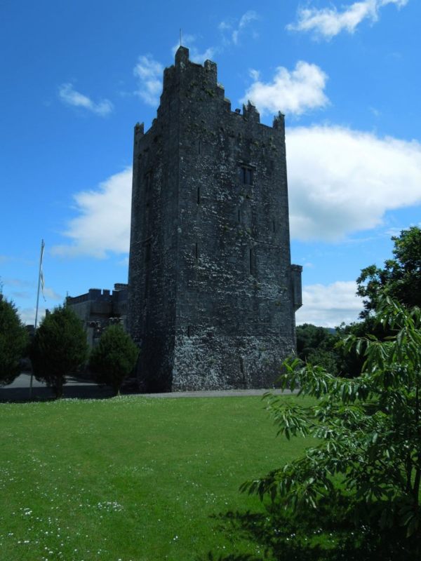
The imposing tower of Blackwater Castle completed by 1475.
Book of Fermoy or Book of Roche
This remarkable manuscript, largely written in the 14th century and up to the 16th century, was written under the patronage of the Lords Roche in the Castle which was then viewed as
“the fortress of the authors and ollavs and exiles and Companies of Scholars of Ireland and from which none ever departed without being grateful”.
Description of Roche Castle from 1561 taken from the Book of Fermoy as cited in Historical and Topographical Notes, County Cork, collected by Colonel James Grove White, published 1906 – 1915 p 151.
Evidently, as wealthy and powerful overlords, the Roches were keen to have their exploits and achievements recorded and preserved for posterity. The result was fostering the tradition of scholarship, storytelling, record keeping and patronage of the arts, in particular that of poetry, as this was how the heroics of the Lords Roche and the beauty and virtues of their womenfolk could be itemised, glorified and disseminated. The Manuscript contains much on the Roche family, their geneaology, land holdings and exploits, but it also contains a number of bardic poems and prose tracts on the general history and pre-history of Ireland, and an extensive collection of legendary, mythological, and Fenian tales along with transcribed fragments of medical treatises on bodily organs such as the liver. The manuscript is one of a small number of surviving medieval manuscripts which was rebound in 1975 is now housed in the Special Collections section of the Royal Irish Academy.
Below is an extract from The Book of Fermoy courtesy of The Royal Irish Academy.

Architectural Importance of Blackwater Castle
Apart from the archaeological value of Blackwater Castle it is also of significant importance from an architectural perspective given that the site comprises buildings dating from the 12th Century which have evolved over time to the fine set of structures we see today. The habitable sections of the house date from the early 15th century making Blackwater Castle one of the oldest habitable houses in Ireland. After the Cromwellian wars the house was rebuilt on the site of the then existing and damaged house in the late 17th or early 18th century “incorporating some of the old walls of the Castle” (Archaeological Survey of Ireland, Vol IV, North Cork, Part 2, Duchas p 650).
You can see the various elements on the Archaeology.ie site by clicking on the red dots for more detail in our townland of Castlewidenham. These entries are currently being updated as the initial entries were done some 30 – 40 years ago without the benefit of adequate access or time for a proper appraisal of the site. More treasures are being revealed as further detailed work is ongoing.
http://webgis.archaeology.ie/historicenvironment/
The following is an account of the architectural features of the site from the National Inventory of Architectural Heritage:
Blackwater Castle – Description
“Detached former country house comprising medieval tower house altered and extended in eighteenth and nineteenth centuries, now in use as hotel. Four-storey tower house, built c.1475, with two-storey over basement country house proper gradually added to south-east. Garden elevation comprises eight-bay block and slightly lower three-bay block, all provided with castellated parapets. Entrance front reveals more of history of building. Comprises three-bay block next to tower house having half-octagonal single-storey porch, all built c.1790, with castellations and corner turrets. Next is slightly advanced six-bay block, south-east half being slightly lower and corresponding to lower three bays of garden elevation.Multiple-bay single-storey outbuilding to south-east. Later blocks are c. 1825. Stepped battlements to tower house. Tooled limestone castellations to garden elevation having panel details and supported on moulded corbelling, with more elaborate pointed arch corbel table to eight-bay part and to three bays of entrance front next to tower house.Corner turrets to garden elevation. Painted rendered castellations to entrance elevation. Rendered walls to garden elevation and entrance elevation of block next to tower house. Coursed limestone rubble walls elsewhere, battered to north-west gable end of garden elevation and visible north-west gable end of middle block of entrance elevation. Tower house has square-headed mullioned two-light windows and loop windows, and pointed arch doorway with replacement timber door, set into chamfered limestone doorway set into square-headed chamfered limestone recess, approached by flight of limestone steps. Square-headed window openings to country house proper, having moulded render label-mouldings and replacement timber casement windows, with limestone sills. Lancet windows with replacement timber frames flank doorway to porch. Tudor arch doorway to porch having moulded render surround and double-leaf timber panelled door. Round-headed doorway to garden elevation middle block, with chamfered limestone surround, hood-moulding and replacement glazed timber doors, with limestone step. Square-headed door opening to garden elevation having render label-moulding and replacement glazed timber door, with flight of limestone steps. Some cast-iron boundary fencing. Courtyard of outbuildings to north.
Appraisal
This site represents more than five hundred years of building with fabric dating from the fifteenth to the twentieth centuries. The country house proper replaces a house of c.1700 and indeed parts of the main house appear to incorporate medieval or seventeenth-century fabric. It is situated on an upland area in picturesque grounds along the river Awbeg and has a striking profile. The dramatic and fanciful castellations contrast with the more functional stepped battlements of the Irish tower house. The label-mouldings also carry on the medieval theme in more modern styles of fenestration. The building’s irregular-plan affords many interesting vantage points.”
The surrounding village of Castletownroche and townland of Castlewidenham also have significant features of architectural, archaelogical and industrial interest and if you would like more information on elements of the architectural heritage of the area do click here. The village has been designated as a “Village of Tradition” and has a rich history as a centre of commercial life, particularly in the 19th century, when it was a bustling hub of activity hosting bakers, joiners, belt-makers, coopers, farriers, harness makers, basket weavers, tailors and dressmakers, nailers and carpenters. See this brochure for further detail on a fascinating insight into village life in the late 19th Century.
Natural Heritage
Finally we should also mention the natural heritage of Blackwater Castle. The site comprises almost 5 acres incorporating native Irish woodland with the Awbeg River flowing through the site. While not a designated Nature Reserve we treat it as such and no hunting is permitted. Our Walled Garden is entirely organic and the grounds are home to a vast array of wildlife including otters, red squirrels, falcons, owls and this summer we suspect (but have not confirmed) that we were visited by an eagle from the Killarney National Park.

A water colour of the then Widenham Castle by Henry Brocas circa 1782.
SOURCES
Researches in the South of Ireland Illustrative of the Scenery, Architectural Remains, and the Manners and Superstitions of the Peasantry, by T. Crofton Croker, 1824.
Historical and Topographical Notes, County Cork, collected by Colonel James Grove White, published 1906 – 1915.
The Roches, Lords of Fermoy: The History of a Norman Irish Family, by Eithne Donnelly, published in Journal of the Cork Historical and Archaelogical Society 1934 – 1937.
The Norman Invasion of Ireland, by Richard Roche, Anvil Books, 1970
The Castles of County Cork, by James N. Healy, The Mercier Press, 1988
The Sub-infeudation and Descent of the FitzStephen/Carew Moiety of Desmond, by Paul McCotter published in Journal of the Cork Historical and Archaelogical Society Vol 102 1997
The Medieval Castles of Ireland, by Davis Sweetman, The Collins Press, 1999
An Anglo-Norman Monastery, Bridgetown Priory and the Architecture of the Augustinian Canons Regular in Ireland by Tadhg O’Keeffe, Cork County Council and Gandon Editions, 1999.
Archaeological Inventory of County Cork, vol IV, parts 1 & 2, Duchas The Heritage Service, 2000.
Blackwater and Bride, Navigation and Trade, 7,000 BC to 2007, by Niall O’Brien, Niall O’Brien Publishing, 2008.
The Old Rustic Bridge, A History of Castletownroche GZ.A., Sport, Culture, and Folklore 1888 – 2008, research by John McHugh & Billy Mannix, compiled by Tommy O’Brien, printed by Carraig Print inc. Litho Press, 2008
An Illustrated Map of the Sheela-na-Gigs of Britain and Ireland, Roberts & McMahon, Bandia Publishing Ireland, 1997.
With thanks to local historian Christy Roche, Fermoy, County Cork and Donal Flynn, Castletownroche.
